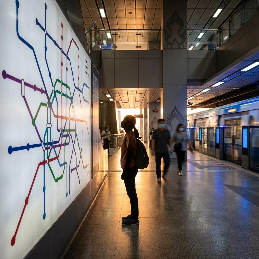
Bangkok Train Map: MRT, BTS & Airport Rail Link
The Bangkok Train Map: covering routes, stations, fares, and transfer tips for easy city navigation.
Unlocking quick, convenient city exploration in Bangkok starts with the metro map, giving you a hassle-free alternative to the city's traffic. This guide breaks down the essentials—MRT, BTS, and Airport Rail Link—to help you get oriented and move smoothly to must-visit places, whether connecting from the airport or navigating to local hotspots.
Your tourist-friendly guide to Bangkok's rail network
The Bangkok metro map is your essential starting point for navigating the city's extensive rail system—a major advantage for international visitors that eliminates the stress of city traffic. The city's interconnected BTS Skytrain, MRT Subway, and Airport Rail Link reach key shopping, business, and entertainment zones. These networks enable reliable, punctual, and affordable transportation to top attractions. They also help you avoid the most common tourist pitfall: getting caught in a traffic jam. Consider using the Bangkok train map for time-sensitive journeys, especially to major sights.
The combined Bangkok MRT and BTS map
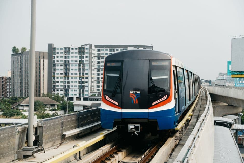
Bangkok BTS Skytrain on elevated tracks, Markus Winkler
Navigate the city with ease using this comprehensive Bangkok MRT and BTS map, which integrates all major BTS Skytrain, MRT Subway, Airport Rail Link, and Gold Line routes as of late 2026. The map highlights each line—BTS Sukhumvit (light green), BTS Silom (dark green), MRT Blue (blue), MRT Purple (purple), and Airport Rail Link (distinct color)—together with important interchange points and terminal stations. Use the color references and letter+number station codes for simple cross-line journeys. Study this combined Bangkok metro map before you plan each day's route for a clear picture of network connectivity.
Last updated: 5 October 2026. Always verify with the latest BTS route-map and MRT map for your travel dates.
Main Bangkok train lines at a glance
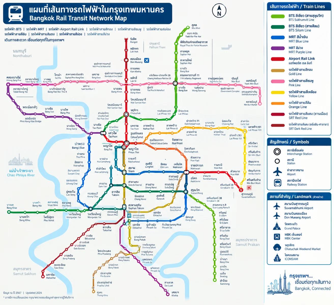
BTS route-map and MRT map
Below is a summary of each major Bangkok urban rail line, including operator, color, key terminals, interchange points, and top reasons tourists use each one. This table is your reference for planning direct and transfer-free journeys, with convenience in mind for sightseeing, shopping, and airport transfers.
| Line | Line color | Operator | Key terminal stations | Primary tourist use | Interchange highlights |
|---|---|---|---|---|---|
| BTS Sukhumvit Line | Light green | BTSC | Khu Khot, Kheha | Central Sukhumvit, Siam, Chatuchak Market, Thong Lo, Ekkamai | BTS Silom Line at Siam; MRT Blue Line at Asok/Sukhumvit, Mo Chit/Chatuchak Park; ARL at Phaya Thai |
| BTS Silom Line | Dark green | BTSC | National Stadium, Bang Wa | Siam, Silom-Sathorn, Saphan Taksin (river boats), Charoen Krung riverside | BTS Sukhumvit Line at Siam; MRT Blue Line at Sala Daeng/Silom; Gold Line at Krung Thonburi; Saphan Taksin pier |
| MRT Blue Line | Blue | BEM | Lak Song, Tha Phra, Tao Poon, Hua Lamphong (loop) | Chinatown, Grand Palace (Sanam Chai), Hua Lamphong, Chatuchak, major central interchanges | BTS Sukhumvit Line at Asok/Sukhumvit, Chatuchak Park/Mo Chit; BTS Silom at Silom/Sala Daeng; ARL at Makkasan/Phetchaburi; Purple Line at Tao Poon |
| MRT Purple Line | Purple | BEM | Khlong Bang Phai, Tao Poon | Access to Nonthaburi, northern suburbs | MRT Blue Line at Tao Poon |
| Airport Rail Link (ARL) | Red/Magenta | State Railway of Thailand | Suvarnabhumi Airport, Phaya Thai | Fast airport transfer, access to Ratchaprarop, Makkasan, Ramkhamhaeng | BTS Sukhumvit Line at Phaya Thai; MRT Blue Line at Makkasan/Phetchaburi |
| Gold Line | Gold | BTSC (special project) | Krung Thonburi, Khlong San | ICONSIAM mall, Charoen Nakhon, riverside district (automated people-mover, short feeder line) | BTS Silom Line at Krung Thonburi |
Note: The Gold Line is a short, automated people-mover linking the BTS at Krung Thonburi to riverside attractions like ICONSIAM. It is not part of the main BTS system and operates separately.
How to read the Bangkok MRT and BTS map
To make the most of your journeys, seasoned travelers benefit from a few advanced strategies when using Bangkok's public transport map:
-
Use color and station code combinations together, rather than relying on just one. Platform signage in busy stations often highlights only the code or color, so cross-reference both to confirm your direction.
-
For multi-line journeys, pre-plan connection points to avoid unnecessary walking. Some interchanges—such as Asok/Sukhumvit or Mo Chit/Chatuchak Park—are directly linked. Others involve multiple escalators or long corridors.
-
During rush hours or station upgrades, certain exits might be closed or rerouted. Check current exit maps on transit apps or at station info boards before arrival.
-
Mind the potential for sign confusion near airport lines or newly opened segments. Refer to the Bangkok MRT map and BTS map and confirm transfers with station staff if unsure.
-
Always carry a backup offline map—such as a screenshot from official sites or apps—to avoid confusion due to spotty mobile data underground. Monitoring your route via the in-train display also helps confirm stops in case of language barriers.
These tricks help you adapt to unexpected changes and streamline tight connections as you travel further afield.
Bangkok train stations for popular tourist attractions
Bangkok's rail network not only connects travellers to major attractions but also offers opportunities for discovering hidden gems. The table below features stations closest to top sights, highlighting unique activities, specialty shopping, or local food courts accessible from each stop. Check exit numbers against station signage, and consider timing your trip to coincide with local markets, festivals, or museum late openings for a richer experience.
| Attraction | Nearest station | Line | Best exit | Walking/onward connection notes |
|---|---|---|---|---|
| Chatuchak Weekend Market | Kamphaeng Phet; Mo Chit (BTS) ↔ Chatuchak Park (MRT) | MRT Blue Line; BTS Sukhumvit Line | Kamphaeng Phet Exit 1 or 2; Mo Chit Exit 1 | Kamphaeng Phet gives the most direct access straight into the market. From Mo Chit, walk through Chatuchak Park to reach the market. Interchange between Mo Chit (BTS) and Chatuchak Park (MRT) as needed. |
| Siam (shopping) | Siam | BTS Sukhumvit Line ↔ BTS Silom Line | Exits 1–4 | Siam is the system's main BTS interchange. Exits lead directly to Siam Paragon, Siam Center, and Siam Discovery via sky walks. Enjoy food courts and pop-up exhibitions within the malls. |
| Sukhumvit (nightlife/hotels) | Asok (BTS) ↔ Sukhumvit (MRT) | BTS Sukhumvit Line ↔ MRT Blue Line | Asok Exits 1–4; Sukhumvit exits for Terminal 21 | Interchange via connected walkways. Explore Terminal 21's themed markets or venture to local izakayas and rooftop bars within walking distance. |
| Silom (business/nightlife) | Sala Daeng (BTS) ↔ Si Lom (MRT) | BTS Silom Line ↔ MRT Blue Line | Sala Daeng Exits 1–4; Si Lom Exit 2 | Direct interchange. Local tip: Silom Road offers night markets, while Soi Patpong hosts both popular bars and vintage market stalls. Chong Nonsi (BTS) is close to Mahanakhon Skywalk for elevated views. |
| Chinatown (Yaowarat) | Wat Mangkon | MRT Blue Line | Exit 1 | For foodies, arrive at dusk for the busiest street food hours. Exit faces Yaowarat Road's lively night scene and specialty gold shops. |
| Grand Palace & Wat Pho | Sanam Chai | MRT Blue Line | Exit 1 (Wat Pho); Grand Palace: walk or boat | Wat Pho is a short walk from Exit 1. For Grand Palace, walk 10–15 min or: Transfer from BTS Saphan Taksin (Silom Line) to Sathorn Pier, then take the Chao Phraya Express Boat to Tha Chang Pier. No direct BTS/MRT for Grand Palace – river transfer required. |
| Wat Arun | Tha Tien connection from Sanam Chai | MRT Blue Line + cross-river ferry | Sanam Chai Exit 1 | Walk from Sanam Chai to Tha Tien Pier, cross river by ferry to Wat Arun. For riverside festivals, visit on weekends. No BTS/MRT on Wat Arun's side – ferry mandatory for access. |
| Khao San Road | No direct BTS/MRT; nearest: Sam Yot | MRT Blue Line | Sam Yot exit toward Old City | About a 20–25 min walk; most take a taxi, tuk-tuk or river boat from Sam Yot, or walk from Phra Arthit Pier. For backpackers, the vibrant scene picks up after dusk. No direct train station – plan for last-mile transfer. |
| Asiatique Riverfront | Saphan Taksin | BTS Silom Line | Exit 2 to Sathorn Pier | Walk to Sathorn Pier; then the free Asiatique shuttle boat runs in evenings. Try the riverside Ferris wheel and street performances. The riverside complex is not directly at the BTS—boat transfer is recommended. |
| Jim Thompson House | National Stadium | BTS Silom Line | Exit 1 | 5–10-minute walk along Soi Kasemsan 2. Siam station is one BTS stop away for Sukhumvit Line transfer. Consider pairing with a visit to Bangkok Art and Culture Centre next door. |
| Lumphini Park | Si Lom (MRT) or Sala Daeng (BTS) | MRT Blue Line; BTS Silom Line | Si Lom Exit 1 or 2; Sala Daeng exits | Si Lom (MRT) is closer to the west park gates; Sala Daeng (BTS) is convenient for northern entrance. Arrive early for morning tai chi or joggers' groups. |
Bangkok's rail system allows easy access to lively neighborhoods and special events. Note the last-mile connections needed for Grand Palace, Wat Arun, and Khao San Road, where a combination of rail, boat, or short taxi ride is recommended for the full local experience.
Getting from the airport to central Bangkok by train
Airport arrivals can get directly into the city with clear train options. From Suvarnabhumi Airport (BKK), take the Airport Rail Link from the lower level of the terminal to Phaya Thai for an easy BTS transfer, or to Makkasan for the MRT Blue Line via nearby Phetchaburi station. The direct ride to Phaya Thai takes roughly 26–30 minutes. Trains run from early morning until midnight with regular departures. Don Mueang Airport (DMK) is served by the SRT Dark Red Line. Board at Don Mueang station, head south to Bang Sue Grand Station, and transfer to the MRT Blue Line. Be sure to confirm the last train timing for late arrivals. Consider a pre-booked transfer or taxi if you land after services end. Use the Bangkok subway map to plan your airport-to-city route in advance for maximum efficiency.
Bangkok train fares and payment options
| Train system | Typical fare | Main payment options | Best for |
|---|---|---|---|
| BTS Skytrain | Around THB 17–65 | Single-journey ticket, Rabbit Card | Sukhumvit, Siam, Silom |
| MRT Blue Line | Around THB 17–45 | Single-journey token, EMV contactless, MRT cards | Old Town, Chinatown, Sukhumvit |
| MRT Purple Line | Around THB 14–42 | Single-journey ticket, EMV contactless | Nonthaburi and northern Bangkok |
| Airport Rail Link | Around THB 15–45 | Single-journey token, supported contactless payment | Suvarnabhumi Airport to central Bangkok |
Bangkok's BTS, MRT, and Airport Rail Link each have their own fares and tickets, sold at stations just before you ride. Single journeys are charged based on distance. Stored-value Rabbit or MRT Plus cards allow for convenient repeat use on their respective networks—these are not interchangeable between systems. For added flexibility, contactless EMV bank cards are accepted on the Airport Rail Link and many MRT stations, but roll-out is still in progress for BTS. For the latest fares and accepted payment types, check the official BTS, MRTA/BEM, and Airport Rail Link websites. Screenshot a printable Bangkok public transport map for easy reference underground or on-the-go.
If you're visiting Bangkok for a few days, you don't need to buy a special transport card just for convenience.
MRT vs BTS in Bangkok: which should tourists use?
| System | Coverage area | Typical tourist use | Ticketing | Station environment | Interchange behavior |
|---|---|---|---|---|---|
| MRT | Blue Line connects Hua Lamphong, Chinatown/Wat Mangkon, Silom, Sukhumvit, Chatuchak, northern Bangkok; Purple Line to outer northwest (mainly residential) | Chinatown, Hua Lamphong, Chatuchak Weekend Market, Old Town, Silom, Terminal 21 via Sukhumvit | Single-journey token, stored-value card, some contactless bank cards. Not interoperable with BTS | Underground, air-conditioned; cooler, less scenic, protected from weather | Requires exiting MRT paid area and entering BTS (new fare). Interchanges: Sukhumvit–Asok, Si Lom–Sala Daeng, Chatuchak Park–Mo Chit |
| BTS Skytrain | Sukhumvit Line (Mo Chit-Phrom Phong-Ekkamai-Asok-Siam-Chit Lom-Phaya Thai) and Silom Line (Siam-National Stadium-Sala Daeng-Surasak, riverside west) | Siam, Chit Lom, Sukhumvit shopping/nightlife/hotels, EmQuartier, Terminal 21, riverside, Chatuchak (via Mo Chit) | Single-journey ticket, Rabbit Card (BTS only), not interoperable with MRT | Elevated, open-air with city views; breezy, exposed to sun/rain, direct mall access | Must exit BTS and enter MRT, pay again. Interchanges: Asok–Sukhumvit, Sala Daeng–Si Lom, Mo Chit–Chatuchak Park |
For sightseeing in Siam or shopping in Sukhumvit, the BTS is often most convenient, especially with its direct mall access and connections to nightlife. The MRT is better for hassle-free trips to Chinatown, Old Town, and train stations. Mix and match lines for maximum coverage—just remember that every interchange requires a new ticket.
Bangkok train FAQ for first-time visitors
Final tips for navigating Bangkok's metro map
For an efficient journey, always prepare your route before you go. Check which interchanges are needed and note station exit numbers specific to your destination. Carry small change for ticket machines and keep a digital or printed Bangkok Skytrain map handy, especially for offline use inside stations. Take note of transfer points such as Siam for BTS lines and Asok/Sukhumvit or Sala Daeng/Silom for BTS/MRT connections. For advanced planning, pair the Bangkok metro map with local event and dining guides to maximize each stop. Explore our Bangkok hotels guide to find accommodation near key rail stations. With the right preparation, Bangkok's rail network is the fastest way to explore city attractions, hidden eateries, how much to bring to Bangkok, and authentic neighborhoods beyond the major tourist sites.
Planning a Bangkok weekend getaway? Book your flight to Bangkok and start planning your next city adventure.

Chayanit P.
1 Oct 2026